Routing options
Table of contents
- The routing options, what do they do?
- An overview of the routing options
- Relationship routing options and surface
- Setting the routing option
- FAQ
- The routing does not follow the path I desire.
- Is there a difference between the routing option "race cycling - nicest" and "recreational cycling (paved only) - nicest"?
- I get the message 'The selected points are too far apart'. Why?
- I can't get certain routing options to show up in the RoutePlanner. Why is that?
- What type of routing should I use for a car
The routing options, what do they do?
When you pin viapoints in the RoutePlanner, a route is calculated between those viapoints using a particular routing method. The most classic routing methods are shortest and fastest way. An additional interesting option in the recreational world is the nicest route. Read here how we determine that at RouteYou.
How routing is done also depends on how the trip is done: on foot, by regular bike, by mountain bike, by horse, by motorcycle, and so on. Therefore, RouteYou offers numerous options that link a specific mode (walking, cycling, ...) and the desired routing method: shortest, fastest or nicest.
An overview of the routing options
- Hiking - nicest: we offer you a route along the nicest walking paths.
- Hiking - shortest: you will be offered the shortest route along paths accessible to hikers.
- Hiking - node network: you are offered a route exclusively via the walking node network.
- Recreational cycling - nicest: we send you along the nicest cycling routes, including unpaved roads in good condition. So this option is not so suitable for a racing cyclist (read more here), but extremely suitable for the recreational cyclist who wants to be fully surprised along beautiful trails and unknown, mostly quiet roads.
- Recreational cycling - shortest: The shortest path you can take as a cyclist, incl. unpaved.
- Recreational cycling - nicest (only paved): We send you along the nicest paved cycling paths. This option avoids unpaved roads, regardless of their condition.
- Recreational cycling - shortest (only paved): you are offered the shortest route via paved roads accessible to cyclists.
- Node-to-node cycling: you are given a route that goes exclusively over the cycling node network. Your route may also include unpaved sections.
- Node-to-node cycling (only paved): you get a route that goes only over the paved parts of the cycling network.
- Node-to-node cycling (avoid climbs): you get a route that goes exclusively over the cycling junction network and avoids climbs as much as possible.
- Race cycling - nicest: We send you along the nicest cycling roads that are especially suitable for road cyclists.
- Race cycling- shortest: You are offered the shortest route suitable for road cyclists.
- Race cycling- nicest (avoid cobblestones): We send you along the nicest cycling roads that are particularly suitable for road cyclists but avoid cobblestones.
- Race cycling- shortest (avoid cobblestones): You are offered the shortest route that is suitable for road cyclists but avoids cobblestone lanes.
- Race cycling- nicest (with car): We will send you along the nicest cycling paths that are particularly suitable for a group of road cyclists accompanied by a support vehicle.
- Race cycling- shortest (with car): You are offered the shortest route suitable for road cyclists accompanied by a support vehicle.
- Mountain bike - nicest: We will send you along the nicest cycling roads that are particularly suitable for MTBs.
- Mountain bike - shortest: You will be offered the shortest route suitable for MTBs.
- MTB Sport Vlaanderen: we send you along the MTB routes mapped out and signposted by Sport Vlaanderen.
- MTB Sport Vlaanderen (all directions): we send you along the mountain bike routes mapped out and signposted by Sport Vlaanderen. And this in the indicated direction as well as in the opposite direction.
- Gravel bike - nicest (winter): We send you along the nicest cycling paths that are particularly suitable for gravel bikers and that are sufficiently accessible in winter. The focus is on 'unpaved trails in good condition'.
- Gravel bike - shortest (winter): You will be offered the shortest trail suitable for gravel bikers and sufficiently accessible in winter. The focus is on 'unpaved trails in good condition'.
- Gravel bike - nicest (summer): We will send you along the nicest cycling paths that are particularly suitable for gravel bikers. Summer-suitable routes also go via unpaved paths that often become inaccessible in winter conditions: 'unpaved paths in poor condition'.
- Gravel bike - shortest (summer): You are offered the shortest trail suitable for gravel bikers. Summer-suitable routes also go via unpaved paths that often become inaccessible in winter conditions: 'unpaved trails in poor condition'.
- Motor - nicest: We send you along the nicest roads that are particularly suitable for motorized vehicles such as motorcycles and cars.
- Motor - shortest: You are offered the shortest route suitable for motorized vehicles such as motorcycles and cars.
- Motor - snelste: We send you along roads where you have the smoothest passage with motorized vehicles such as motorcycles and cars and thus offer the fastest route.
- Equestrian node network: you get a route that goes exclusively over the equestrian node network.
- Inline skating - nicest: We send you along the nicest paved roads (without cobblestones) that are particularly suitable for inline skaters.
- Inline skating - shortest: You are offered the shortest route along paved roads (without cobblestones) suitable for inline skaters.
- Shortest- OSM: You are offered the shortest available route along paths known in OpenStreetmap. No restrictions or properties of those paths are taken into account.
- Manually: In some cases you want to plot a route independently of the map background. Then you will not use routing but manually map out your route point by point (read more about that here).
Attention (!) Not all routing options are available in every country.
Background information on some of the routing options
Each part of the routable network has been classified according to suitability for bicycles, pedestrians, motorised vehicles,... It does not only allow you to calculate the shortest and fastest but also the nicest route.
Nicest route
In addition to the fastest and shortest, we also offer an advanced routing algorithm based on more than 38 parameters to calculate the "nicest" route between two points. That "nicest" depends on your mode choice: hiking, road cycling, mountain biking, motorcycling, ... . There can be much discussion about "most suitable" and "nicest". Therefore, we realize that this is more art than science. Nevertheless, after research we came to the conclusion that professionally designed routes tend to follow specific features of roads and avoid other features. We were able to link more than 85% of this to our ever-growing set of more than 38 parameters: for example, road width, road importance, road crowding, through or along forest areas, along rivers, near lakes, near or through parks, built-up areas, industrial areas, and so on. We hope you find this useful and that it will help you plan a suitable route more quickly.
If you do not agree with our calculation of "suitability," you can modify the route at any time. After all, "Des goûts et des couleurs on ne discute pas".
Road bike with support vehicle
A routing option for road cyclists with a support vehicle (nicest & shortest) is offered. You'll find that option under the route type "Race Cycling route".
This routing option is different from the regular road bike routings (nicest or shortest) because those options give preference to car-free roads. Of course, that is not so convenient if you need to stay with the cyclists with a support vehicle. You could also choose "Motor - nicest", but that may send you over stretches where you can go through by car or motorcycle but not by bicycle. Hence this separate routing option.
Node-to-node cycling - avoid climbs
The routing option "Node-to-node cycling - avoid climbs" allows you to avoid as many climbs as possible. Important here is the "as much as possible" approach. After all, it doesn't mean you won't get any "uphill". Of course, if you have to cross a mountain or hill, you have to go up one way or another. But this option steers you along the least steep side. We also take into account the direction of the slope. Steep downhill is not penalized. Steep upward is. So you may well end up with a different option on the way up versus the way back.
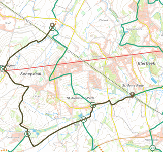
Here is a nice example of the effect of this routing. If you want to cycle from the south of Schepdaal to the north of Schepdaal, you have to go up the sturdy ridge over which the Ninoofsesteenweg (red line) runs. As you can see, there are two node routes. One through Sint-Getrudis-Pede with a more than tough climb, and one along the western part of Schepdaal where there are also slopes but slightly less steep. So you get a slightly longer option but with less steep slopes.
Shortest - OSM
Shortest - OSM stands for "the shortest route along paths known in OpenStreetmap".
With that option, we draw the shortest path along roads and paths known in the OpenStreetMap map. CAUTION! That means we do not take into account whether it is allowed or not (e.g. one-way streets, unpaved, highways,...). If you use this you better know the area well!
TIP! For users who want to redraw a known route from a map, the Shortest OSM option is a very convenient solution.
For example, if you use the option 'Recreational Cycling - nicest' we sometimes send you through sections that we think are better for cycling. And that can be confusing if you know exactly which way you want your route to go.
Relationship routing options and surface
The routing options take many aspects into account, but a very important element is the surface.
In terms of subsoil, we distinguish 4 categories:
- Paved
- Paved - good condition: e.g. asphalt, bricks, concrete slabs...
- Paved - bad condition: e.g. cobblestones, poorly maintained asphalt with deep potholes, ...
- Unpaved
- Unpaved- good condition: e.g. gravel (gravel), vegetation-free soil but well passable
- Unpaved- bad condition: e.g. gravel with many pits, vegetationless ground with many bumps, stretches with a lot of vegetation
In the following matrix you can see which sections
- are allowed per routing
- are preferred for each routing
- are not allowed within each routing
| Paved - good condition | Paved - bad condition | Unpaved- good condition | Unpaved- bad condition | |
|---|---|---|---|---|
| Race cycling (nicest and shortest) | PREFERRED | ALLOWED | ||
| Recreational cycling (nicest and shortest) | PREFERRED | ALLOWED | PREFERRED | |
| MTB | ALLOWED | ALLOWED | PREFERRED | PREFERRED |
| Hiking | ALLOWED | ALLOWED | PREFERRED | PREFERRED |
An example to illustrate how to read the table:
- If you choose the routing option "Recreational Cycling - nicest", you can preferably expect paved (good condition) surface or unpaved (good condition) surface such as gravel. You may also find sections of paved surface in bad condition, but these are rather exceptional. You should expect to find NO sections that are unpaved and in bad condition.
Note! This is only one of many parameters used in the routing options. For example, read more about the nicest routing here.
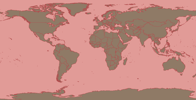
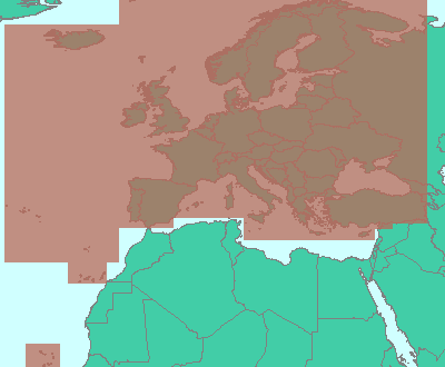
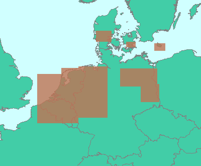
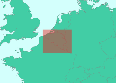
In which areas are which routing options available?
| Routing | Area |
|---|---|
|
Recreational cycling - nicest, shortest |
 |
|
Recreational cycling - nicest (only paved)
|
 |
|
Recreational cycling - node network
|
 |
|
Race cycling - shortest (avoid climbs) |
 |
Setting the routing option
In the RoutePlanner, under the Plan module, you will find the "Routing" option. Here you can select the type of routing you want. The list is long but depending on your choice at the " Routetype" section, the available list will be shortened. We only show the routing options that are appropriate for the chosen Routetype.
If you add a viapoint or move it, you will see the effect. The route will be (re)calculated according to the selected routing option.
What happens if you change routing?
If you change routing during or after creating a route, you will be asked if you wish to apply the new routing to:
- the entire route
- the following changes
Apply to the entire route
>> In this case, the entire route will be recalculated according to the new routing.
Suppose you had already mapped out a route A to B to C to D. If you choose the first option where the new routing is applied to the entire route, then each section of the route already created (A-B, B-C, C-D) will be recalculated according to the newly chosen routing.
Apply to the following changes
>> Only the section of route that you still intend to plan or modify will be (re)calculated according to the new routing.
Suppose you already planned a route A to B to C to D and you choose the second option where the new routing is only applied to the next changes.
Then depending on your actions this may have a different effect:
The possibilities:
- Add an extra point at the end of your route: if you add an extra point E to your route, then only route D-E will be calculated according to the new routing. The trajectories A-B, B-C, C-D remain unchanged.
- Adding an additional point between two existing points: between points B and C, click on the trajectory and drag that point to a specific place. Let's call that point P. Then the trajectory B-P and P-C will be recalculated according to the newly set routing. The trajectories A-B, C-D remain unchanged.
- Moving an existing point: drag point C to a new position, then the trajectory B-C and C-D is recalculated according to the newly set routing. The trajectory A-B remains unchanged.
FAQ
The routing does not follow the path I desire.
If you wish to go via small (unpaved) paths, it is best to choose "shortest - OSM". Attention! In this case, it does not take into account the restrictions of a path such as one-way streets or paths with limited access, and so on. The system follows the available network regardless of the modes you plan for.
If you want full control to plan your route and also go through paths that are not (yet) included in the network, you can also switch to "manual" routing.
Is there a difference between the routing option "race cycling - nicest" and "recreational cycling (paved only) - nicest"?
It's true that both the routing option 'race cycling - nicest' and 'recreational cycling (paved only) - nicest' send you over paved stretches of road. But what is the difference?
- With 'race cycling - nicest' we are not going to send you over very narrow (paved) paths. With 'recreational cycling (paved only) - nicest' we are.
- With 'race cycling - nicest' we're not going to make you turn left/right too much to keep up cadence. Because of this you might be missing out on fun short lanes . With 'recreational cycling (paved only) - nicest' we don't take that cadence into account, with the result that you do get sent over more fun short lanes.
- With 'race cycling - nicest' we are going to send you more along cyling paths that overlap with existing road bike type routes. With 'recreational cycling (paved only) - nicest' we're going to send you more along cyling paths that overlap with existing routes of the recreational cycling type.
I get the message 'The selected points are too far apart'. Why?
With some routing options, it takes a little more time to calculate the nicest path. Therefore, we limit the distance between two viapoints to avoid a long wait. You can solve this by adding an extra viapoint to limit the distance between viapoints to a maximum of 300 km.
I can't get certain routing options to show up in the RoutePlanner. Why is that?
- Option 1 - 'manual is missing': Presumably you selected the "Round trip" option when planning. With a Round trip, we don't offer the 'manual' (or 'shortest') option because then we always calculate a route over the network. The 'manual' option is just meant to not go over the network. So with a 'Round trip' that is a contradiction.
Also the option 'shortest' is not available here because we want to offer you a Round trip. The shortest option would then be to just stay at the starting point.
>> SOLUTION: If you choose the "From A to B" option in the planner, you will see that you do get the options 'manual' (or 'shortest').
- Option 2 - 'I don't see hiking routings': The routing options you get always depend on the route type. For example, if you select the " cycling " type, then we don't offer hiking routing like 'Hiking - nicest'.
>> SOLUTION: If you choose the correct route type you will get the relevant options.
- Option 3: Not all the regions of the world have the same options in terms of routing options. Certain routing options are not relevant in certain regions because they simply do not exist. An example is "'Hiking -Node network'. Not everywhere in the world there are already hiking node networks available. Also, in "remote areas" we may not yet have all the data to offer routing.
What type of routing should I use for a car
The best routing to use for a car is the option:
- Motor - nicest
- Motor - shortest
- Motor - fastest
The path calculated for Motor are roads you can always enter by car. So depending on your goal, you select, shortest, fasters or nicest. For leasure purposes (e.g. a tour to do with oldtimes cars,...) we advize you to select Motor - nicest (read here more about it). The moment you save the route, you can still indicate if it is a car route, or specifically an oldtime route,...