Maproulette
This page contains a demo on how to fix OpenStreetMap data with Maproulette
What is Maproulette?
Maproulette is a tool designed by the OpenStreetMap community and lets you create and manage micro-tasks in OpenStreetMap. A challenge contains a limited set of tasks. You need an OpenStreetMap account to participate. Register here.
How do we use it?
We use Maproulette to create challenges which contains tasks resulting from a match between proprietary data and OpenStreetMap. Each challenge contains a limited set of conflicts (≈ tasks) between both and limited to a certain mode (bicycle, horse riding, walking, ...).
Overview of challenges
| Status | Dataset | Mode | Description | Match Distance | url |
|---|---|---|---|---|---|
| OPEN | Paths Brussels | Horse | Conflict between proprietary data and OpenStreetMap for mode horse. Ways in OpenStreetMap have explicit tag limiting access for mode horse. | 10 m | link |
| OPEN | Paths Brussels | Bicycle | Conflict between proprietary data and OpenStreetMap for mode bike. Ways in OpenStreetMap have explicit tags limiting access for mode bike. | 10 m | link |
| OPEN | Paths Brussels | Walking | Conflict between proprietary data and OpenStreetMap for mode bike. Ways in OpenStreetMap have explicit tags limiting access for walking. | 10 m | link |
| OPEN | Paths Brussels | Bicycle | Conflict between proprietary data and OpenStreetMap for mode bike. Ways in OpenStreetMap have no explicit tags limiting access for bicycle. | 10 m | link |
| OPEN | Paths Brussels | Walking | Conflict between proprietary data and OpenStreetMap for walking. Ways in OpenStreetMap have no explicit tags limiting access for walking. | 10 m | link |
| OPEN | Paths Brussels | Horse | Conflict between proprietary data and OpenStreetMap for horse riding. Ways in OpenStreetMap have no explicit tags limiting access for horse riding. | 10 m | link |
| OPEN | Paden Vlaanderen | Bicycle | Conflict between proprietary data and OpenStreetMap for mode bike. Ways in OpenStreetMap have explicit tags limiting access for mode bike. | 10 m | link |
| OPEN | Paden Vlaanderen | Horse | Conflict between proprietary data and OpenStreetMap for mode horse riding. Ways in OpenStreetMap have explicit tags limiting access for horse. | 10 m | link |
| OPEN | Paden Vlaanderen | Bicycle | Conflict between proprietary data and OpenStreetMap for mode bike. Ways in OpenStreetMap have no explicit tags limiting access for bicycle. | 10 m | link |
| OPEN | Paden Vlaanderen | Horse | Conflict between proprietary data and OpenStreetMap for mode horse. Ways in OpenStreetMap have no explicit tags limiting access for horse riding. | 10 m | link |
| OPEN | Paden Vlaanderen / Paden Brussel / Paden Wallonië | All | Paths with a very low or no match between OpenStreetMap and proprietary data | 10 m | link |
| OPEN | Paden Vlaanderen / Paden Brussel / Paden Wallonië | All | Paths with a high match which have a name in the proprietary dataset but not in OpenStreetMap | 10 m | link |
Tutorial
- After signing in with your OSM account, go to one of the challenges with the links in the above table
- You can start going through a challenge with the 'Start' button. You will see the first task and ways to complete the task:
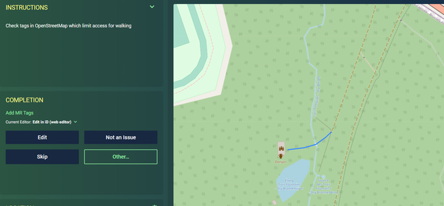
- Edit: the task if valid and changes in OSM are necessary. When you click 'Edit' you will be guided to the OpenStreetMap editor (default ID). Complete the task when returning to maproulette.
- Not an issue: the task is not valid. You can add a comment when chosing this status.
- Skip: skip this task
- Other: Choose another status
- When you completed the task, you will get a confirimation dialogue screen where you can add a comment and go to the next task

More generic toturials are also available on YouTube
FAQ
A task is created but I see no problem
All tasks are created based on a match between proprietary data and OpenStreetMap. Where several paths run parallel within the match distance it is possible that a task is created by a mismatch. If it is a clear mismatch, flag the task as 'not an issue'. If you want more information on this tasks, flag it as 'Too hard / Can't see' and add a comment.