RouteYou Map
Table of contents
- What is the RouteYou map
- Specific features of the RouteYou map
- Legend of the RouteYou map
- Difference from other map layers
What is the RouteYou map
The RouteYou map shown as the default map layer was developed with a focus on outdoor route planning and outdoor navigation.
It was therefore chosen to show only the information that is essential for those two purposes. In this way, you're not distracted by an overdose of information.
The map is based on OpenStreetMap and is hosted with and offered by Thunderforest's technology.
Specific features of the RouteYou map
The map can be oriented in any direction, an essential feature in navigation. This way, you're always able to read the labels on the map.
Legend of the RouteYou map
Lines
Orange: motorways & trunk roads

Yellow: Main roads; primary (yellow with orange border) and secondary roads (yellow with grey border) with road numbers

White: roads mainly intended for cars, but of lesser importance than roads with previous colours

Dotted line as edge on above roads: tunnel


Blue dotted line: paved cycle paths - car-free
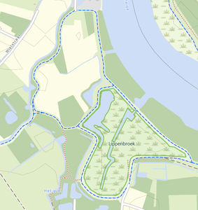
brown-red dotted line: paths for pedestrians

Wide dark brown dotted line: stairs

Green dotted line: paths for horse riders

Blue-red dotted line: other paths mainly on which mixed use is allowed. For example, walkers and cyclists.

Brown long dotted line/full line: wide paths usually intended for mixed use. The full line is used if the path is paved.

Full thin grey line: railway / tram / pre-metro / historic railway lines

Blue line: streams and rivers

Thin grey continuous line: contour lines (height in meters)

Full green line: boundary of protected nature areas, parks, ...

Solid black line: country border

Black dotted line: province/state borders or similar

Light grey line: municipal boundary or similar

Traffic flow
Light grey arrows: one-way traffic

Accesibility
Roads and paths that have restricted access for all modes (e.g. private)


In detail
Gate

Bollard
![]()
Labels
Country

Region (State, province, departement,...)

Big city
![]()
Medium sized city (middle), small city / big village (right), village (left)

Districts, hamlets and small villages
![]()
Parks and protected areas

Streetname
![]()
Name of watercourse / -surface
![]()
Religious centres

Monuments, commemorative plaques, ...

Mountains, hills, peaks,...

Mountain hut

House number

Areas
Light grey: built-up area
Dark green: forest
Light green: meadows and other grasslands
Light yellow: farmland

Greenish yellow (top left): no land use information available

Dark grey: buildings & building complexes
Light green grass icon: lakes, marshes and wetlands

Dark grey dots: debris, loose stones, ...

Blue: water (rivers, canals, lakes, seas, ...)

Bright green: protected areas, parks, ...

Difference from other map layers
Example - Lyndhurst, England
This set of maps shows the difference between the RouteYou map and other map options availaible on RouteYou.
The maps are shown in this order: (1) RouteYou map, (2) Google Maps, (3) OpenStreetMap, (4) Topo map Great Britain (OS).


