Roadbook
Continguts
Purpose?
The purpose of the roadbook is to have a practical combination of detailed maps and a list of instructions with which you can easily follow a route on the terrain.
For an overview of all print options, click here.
For whom?
The road book is accessible to every RouteYou user. However, the print options are determined by your account level:
- With a free account you can adjust the following items:
- the orientation of your map: portrait or landscape
- the detaillevel of the map tiles: with this you determine the scale of your map(s), the higher the level of detail, the greater the map scale. This may result in more map tiles.
Attention (!) there is also such a thing as a minimum zoom level. The scale level can be reduced to a maximum until one side of the map is 1 km. With a short route there may therefore be little or no difference between the different levels. - the output format: a pdf or an image (png format).
- From a Plus account you have more options:
- If available, you can print the route on a topographical background. Attention (!) a print with a topographical map is only intended for individual, personal use. For large print runs in the context of an event, for example, royalties must be paid.
- Decide for yourself how many card tiles per page you want to print: you can choose between one, two, four, six or eight card cuts per page.
- Choose whether or not to show the places of interest.
- From a Premium account you can choose to:
- Print your route on a different paper size than the standard A4.
- Change the style of your map(s) to Contrast, Accent, Bright, Gray or Retro.
- Whether or not display the nodes on the map prints for node routes.
For more information about all print options, click here.
Layout
Map tiles
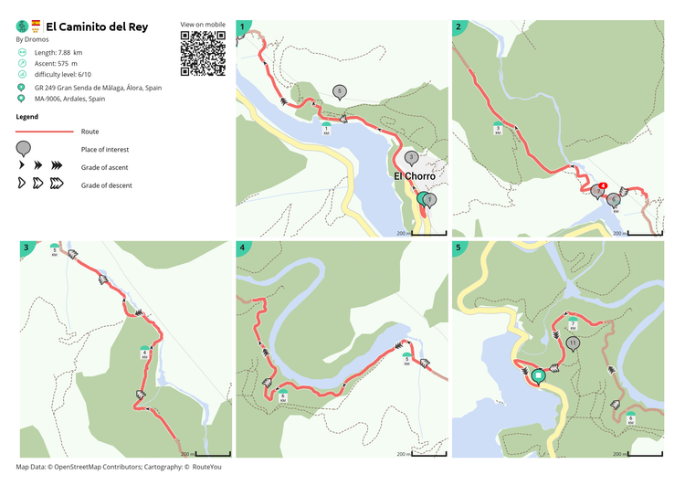
In the roadbook the overview map is split into smaller and more detailed maps. When you have finished the route on map number 1, continue to map 2, and so on.
The map tiles also provide an indication of the steepness of the ascent or descent.

Street names and instruction list
Below the map tiles you will find an instruction list. It consists of 6 columns:

- Total: this is the total distance traveled along the route at the given location.
- Type: symbolic representation of the start and end points, the instructions, the points of interest or the nodes.
> If the points of interest are too close together, two consecutive points may have the same number. - Map number: this refers to the number in the top left corner of the map tiles. This way you can easily find the location of the point of interest, the junction or the instruction.
- Information: this is a limited amount of information accompanying the item. This can include the following:
- Street name: the street name the instruction refers to
- Title of the point of interest: the name of the Landmark
- Node: From-to node info
- Timetable 15 km/h: this shows the total time you were on the road at a given location. Assuming you are moving at a speed of 15 km per hour. The average speed that is applied depends on the way in which you as a user will move: on foot, by bicycle, by car, ... .
- Next: the distance to the next instruction.
Frequently Asked Questions
Why do some routes not show instructions?
- When you or another author creates a route you can choose the routing. With that routing, the path is calculated over the available road and path network. Because the route then runs over that network, instructions are also calculated. These instructions indicate things like "diagonally right on Stijn Streveulslaan". Almost all routing options do this. There is one exception, namely the routing 'manual' (read more about manual here). In that case you deliberately choose NOT to match with the underlying network and no instructions are calculated.
- You can also upload a route to RouteYou. There is an option there that does NOT match the route to the underlying network. So even then you won't get any instructions. That is the same effect as if you were to draw the route manually.
- There is no information (e.g. street names) available.
Is there anything you can do about that?
Option 1: It is your own route
Yes indeed. If it is your own route, you can edit it using the route planner (read more about it here).
- The routing in the planner will be set to MANUAL.
- Change it to OSM shortest or another routing
- When asked "What do you want to apply this routing to?" A: "Full route" or B: "Next changes", choose A. The full route will then be matched with the underlying network. And instructions are calculated.
Option 2: It is a route of someone else
- Download de GPX van de route (read more about that here)
- Load the GPX and choose the default options with "Recalculate on existing roads where possible"(read more about that here)