Height profile
What is a height profile?
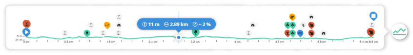
A height profile shows the trajectory of a route in a graph: on the vertical y-axis the altitude meters are plotted and on the horizontal x-axis the distance or length meters. The result is thus a profile display on which you can see the ascent and descent of a route.
Extra information
On the RouteYou height profile we have visually incorporated additional information:
- If there are places of interest attached to your route then these are also shown at the correct location along your elevation profile.
- If you are using the RouteYou Turn-by-Turn navigation then your avatar will also appear on the elevation profile. So you can perfectly trace where you are on the route.
- If you hover with your mouse over the route line on the map or elevation profile, you will also see a horizontal bar with concise practical information at that location in the height profile. It tells you
- the altitude of the respective location (read more about how RouteYou calculates altitude data here)
- the distance you have traveled from the starting point
- and the gradient of the indicated location
Where to find the elevation profile
For each route on RouteYou, you can display or disable a corresponding height profile. You can do that via a button on the map:  .
.
This button can be found in both the RouteViewer as well as the RoutePlanner as soon as you start planning.